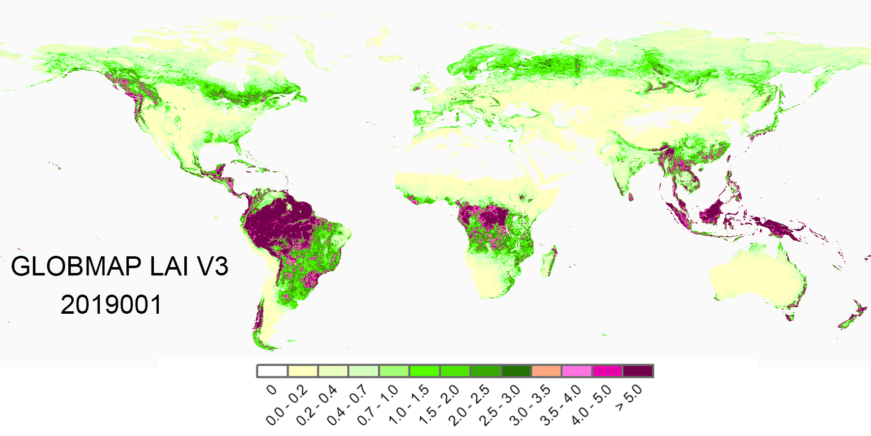
GLOBMAP 全球叶面积指数产品 (Version 3)
GLOBMAP Leaf Area Index (LAI) Version 3 Description
引用 (使用该数据时请引用如下文章):
Citation (Please cite this paper whenever these data are used):
Liu, Y., R. Liu, and J. M. Chen (2012), Retrospective retrieval of long-term consistent global leaf area index (1981–2011) from combined AVHRR and MODIS data, J. Geophys. Res., 117, G04003, doi:10.1029/2012JG002084.
产品说明
GLOBMAP叶面积指数产品 (Version 3) 提供了全球1981年以来的高一致性长时间序列叶面积指数(Leaf Area Index, LAI)数据,产品持续更新。数据覆盖全球植被区域,空间分辨率为8km,采用经纬度坐标。产品基于AVHRR和MODIS数据定量融合反演得到,2000年前后分别为AVHRR和MODIS数据反演结果。算法首先基于MODIS地表反射率产品MOD09A1利用GLOBCARBON LAI算法(Deng et al., 2006)反演得到MODIS LAI序列,然后基于两个传感器的重叠观测构建AVHRR GIMMS NDVI与MODIS LAI像元级的关系,并基于该关系回溯反演了AVHRR LAI。详细算法请参考Liu et al., (2012)。

Version 3相对于JGR文章的变化:
(1).利用MODIS C6地表反射率产品MOD09A1生成MODIS LAI,替换了JGR文章中采用的C5产品。
(2).采用全球集聚指数图(500m分辨率)(He et al., 2012)从像元尺度考虑植被的聚集效应,替换了JGR文章中MODIS LAI反演采用的土地覆盖类别的集聚指数。
(3).MOD09A1云掩膜采用了基于时间序列地表反射率拐点的云检测算法(Liu and Liu, 2013),并利用局部调整三次样条插值方法LACC (Chen et al., 2006)对缺失值和噪音进行插值平滑。
Product Description
GLOBMAP LAI Version 3 provides a consistent long-term global leaf area index (LAI) product (1981-2017) at 8km resolution on Geographic grid by quantitative fusion of Moderate Resolution Imaging Spectroradiometer (MODIS) and historical Advanced Very High Resolution Radiometer (AVHRR) data. The long-term LAI series was made up by combination of AVHRR LAI (1981–1999) and MODIS LAI (2000–2017). MODIS LAI series was generated from MODIS land surface reflectance data (MOD09A1) based on the GLOBCARBON LAI algorithm (Deng et al., 2006). The relationships between AVHRR observations (GIMMS NDVI (Tucker et al., 2005)) and MODIS LAI were established pixel by pixel using two data series during overlapped period (2000–2006). Then the AVHRR LAI back to 1981 was estimated from historical AVHRR observations based on these pixel-level relationships. Detailed descriptions of algorithm and evaluation of the algorithm see Liu et al. (2012).
Several changes have been made compared with the JGR paper:
(1).The MODIS C6 land surface reflectance products MOD09A1 was used to generate MODIS LAI in this GLOBMAP V3 products instead of C5 products.
(2).The clumping effects was considered at the pixel level by employing global clumping index map at 500m resolution (He et al., 2012) instead of land cover-specific clumping index in generation of MODIS LAI. And the new pixel-based AVHRR SR-MODIS LAI relationships were established based on these MODIS LAI series and used for AVHRR LAI retrieval.
(3).The cloud mask for MOD09A1 data were generated by a new cloud detection algorithm based on time series surface reflectance observations (Liu and Liu, 2013). And the contaminated pixels were filled by locally adjusted cubic spline capping approach (Chen et al., 2006), which is different from version 1.
数据说明
Dataset Characteristics
Spatial Coverage:180oW~180oE, 63oS~90oN
Temporal Coverage:July, 1981 - December, 2019
Spatial Resolution:0.08o
Temporal Resolution:Half month (1981-1999), 8-day (2000-2019)
Projection:Geographic
Data Format:GeoTIFF, HDF
Input Data:AVHRR GIMMS NDVI (1981-1999)
MODIS land surface reflectance (MOD09A1 C6) (2000-2019)
Scale: 0.01
Valid Range:0, 1000
参考文献
Reference
(1).Chen, J. M., F. Deng, and M. Chen (2006), Locally adjusted cubic-spline capping for reconstructing seasonal trajectories of a satellite-derived surface parameter, IEEE Trans. Geosci. Remote Sens., 44, 2230-2238
(2).Deng, F., J. M. Chen, S. Plummer, M. Z. Chen, and J. Pisek (2006), Algorithm for global leaf area index retrieval using satellite imagery, IEEE Trans. Geosci. Remote Sens., 44(8), 2219–2229.
(3).He, L. M., J. M. Chen, J. Pisek, C. B. Schaaf, and A. H. Strahler (2012), Global clumping index map derived from the MODIS BRDF product, Remote Sens. Environ., 119, 118-130.
(4).Liu, R. G., and Y. Liu (2013), Generation of new cloud masks from MODIS land surface reflectance products, Remote Sens. Environ., 133, 21-37.
(5).Tucker, C. J., J. E. Pinzon, M. E. Brown, D. A. Slayback, E. W. Pak,R. Mahoney, E. F. Vermote, and N. El Saleous (2005), An extended AVHRR 8-km NDVI dataset compatible with MODIS and SPOT vegetation NDVI data, Int. J. Remote Sens., 26(20), 4485–4498.